TOKYO, Sept. 24, 2025 /PRNewswire/ — Intent Exchange, Inc. (“Intent Exchange”), NEC Corporation (“NEC”), and NTT DATA Japan Corporation (“NTT DATA”) today announced the pilot deployment of Unmanned Aircraft System Traffic Management (“UTM”) system at Expo 2025 Osaka, Kansai, Japan (“the Expo”). The System is designed to provide unified monitoring of drone and advanced air mobility (“AAM”) operations within and around the Expo site. The pilot operation will be conducted from August 16 to October 13, 2025, with the aim of validating usability from an operator’s perspective and defining functional requirements for future UTM.
【Background】


Drones and AAM are gaining attention as next-generation air mobility solutions. However, low-altitude airspace is already used by conventional aircraft, making safe and efficient traffic management essential. To address this, international efforts are underway to establish and standardize regulatory frameworks for Unmanned Aircraft Systems Traffic Management (“UTM”). In Japan, the “Policy on Institutional Development for UTM”[1] has been set forth, alongside the government-operated Drone/UAS Information Platform System (“DIPS2.0”) [2], and discussions are progressing to establish a certification framework for private UTM Service Providers (“USPs”).
Intent Exchange, NEC, and NTT DATA are participating in the Realization of Advanced Air Mobility Project (“ReAMo Project”)[3] promoted by the New Energy and Industrial Technology Development Organization (“NEDO”), contributing to UTM technology development, testing, and policy recommendations. As drones and AAM will be operated at the Expo site, the three companies will jointly conduct a pilot deployment of the System as part of the ReAMo Project to enhance safe air operations.
【Overview of the Pilot Deployment】
At the Expo site, the following functions have been provided on a trial basis for the Drone Traffic Management Team, EXPO Vertiport operator (ORIX Corporation), and AAM operators such as SkyDrive Inc., and their operational feasibility will be evaluated. The Drone Traffic Management Team is comprised of General Incorporated Association Japan UAS Industrial Development Association (“JUIDA”) and Blue innovation Co., Ltd. (“Blue innovation”) [4]:
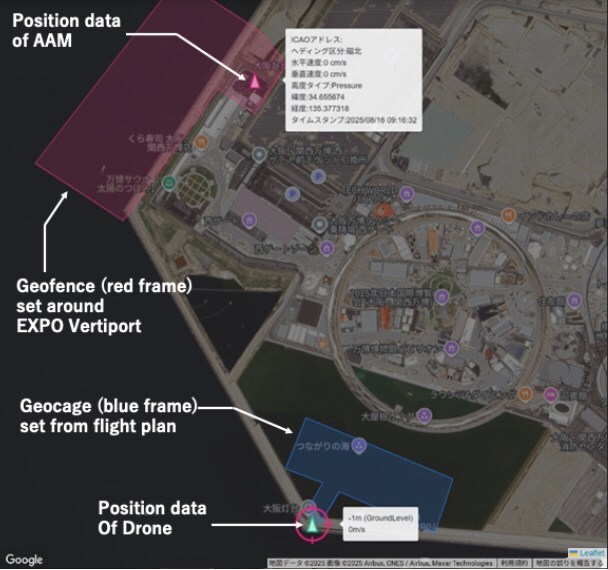
- Geofence Setting by Vertiport Operator
A geofence is a virtual boundary within which drone flights are prohibited. Using Intent Exchange’s USP, EXPO Vertiport operator can set geofences for their designated airspace. This enables drone operators to clearly identify no-fly zones. By comparing drone position data with these virtual boundaries, it is also possible to determine whether a drone is entering a geofenced area. - Geocage Setting Based on Flight Plans
A geocage is a designated airspace within which a drone is scheduled to operate. Geocages are defined using flight plans that drone operators file with DIPS2.0 or submit via Intent Exchange’s USP. By comparing actual drone position data with these geocages, it becomes possible to detect any deviations from the planned flight path. - Real-Time Drone Positioning via Remote ID
Remote ID is a function and regulatory framework that enables drones to broadcast their identification and position data. In principle, all drones operating in Japan are required to be equipped with this transmission capability. At the Expo site, NEC will install Remote ID receivers to capture drone position data and share it with other USPs. This allows the Drone Traffic Management Team, EXPO Vertiport operator, and AAM operators accessing USP platforms to monitor drone flight positions in real time. - Real-Time Positioning of Manned Aircraft
ADS-B (Automatic Dependent Surveillance–Broadcast) signals transmitted by conventional aircraft and AAM will be received by low-altitude receivers developed by the Japan Aerospace Exploration Agency (“JAXA”). ADS-B is a system that broadcasts an aircraft’s position data. The acquired data will be relayed to NTT DATA’s surveillance SDSP (Supplemental Data Service Provider). A surveillance SDSP is a service provider that collects aircraft position data from multiple sources and distributes it to operators who require it. Intent Exchange’s USP will use high-altitude position data provided by the SDSP to detect approaching manned aircraft and display this to the Drone Traffic Management Team and drone operators, thereby enhancing the safe operation of drones. - Detection and Notification of Geofence Incursions and Geocage Deviations
The USP manages information on geofences and geocages for each operation and uses real-time drone position data obtained via Remote ID to detect any deviations from geocages or incursions into geofenced areas. When such events are identified, notifications are sent—via email or other means—to relevant stakeholders, including the Drone Traffic Management Team, EXPO Vertiport operator, and AAM operators.

Figure 1. Excerpt from USP Interface; Note: In this verification, no drones were flown during or immediately before and after the operation of AAM; only Remote ID signals were received and displayed.
【Future Outlook】
Through this pilot, Intent Exchange, NEC, and NTT DATA will validate the operational feasibility of the drone traffic management system. The findings will be compiled into proposed service requirements for USPs and fed back to the Civil Aviation Bureau of the Ministry of Land, Infrastructure, Transport and Tourism (“MLIT”) as input for discussions on the requirements of the certified USP framework.
According to the policy on the institutional development of the certified USP framework, UTM based on DIPS2.0 is positioned as Step 1, while UTM involving USPs is positioned as Step 2. At the initial stage of Step 2, required functions include the provision of manned aircraft position data, while the mid-to-late stage of Step 2 requires monitoring drone position and ensuring compliance between flight plans and actual operations. This pilot deployment corresponds to Step 2 functionality.
Furthermore, the knowledge gained from this initiative will be utilized in JAXA’s work on developing an integrated architecture for traffic management systems, enabling new forms of air mobility such as drones and AAM vehicles to safely and freely share the skies.
|
References:
|
【Media Contact】
|
Intent Exchange, Inc. Email: [email protected]
NEC Corporation Smart City Business Development Department, Infrastructure DX Business Division Email: [email protected]
NTT DATA Japan Corporation Mobility and Resilience Division, First Public Sector Email: [email protected] |
